I have fallen in love with Assynt on my first visit a few years back, and have been coming back at every opportunity since. Assynt is, without any doubt, the leading contender for the most beautiful and unspoiled area in the whole of Scotland. It also provides some excellent off road (and more often than not, off track) running opportunities, usually in complete solitude, just in the company
of deer and golden eagles.
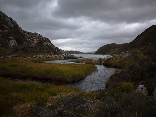
Kirkaig Falls
Kirkaig Falls are a favourite destination with visitors to the area. The lovely, rocky, path leading from a car park just south of Inverkirkaig (follow signs for a bookstore; NC 086 193) is good run its own right, and worth doing even if you are just passing. Post run cakes can be had from the bookstore!
10km / 220m ascent (13km if taken all the way to head of Fionn Loch)
While a good run in its own right, the Kirkaig Falls path also provides access onto the elevated plateau dominated by the iconic Suilven, which offers additional opportunities.
Round of Fionn Loch
This is an excellent, guaranteed wet feet outing, taking you onto pristine ground rich in wildlife, with a couple of unavoidable, and substantial, river crossings.
Start as for Kirkaig Falls. Just before the falls, the path splits at
a warning sign; take the left fork continuing on to Fionn Loch. About 3/4km further on a path breaks off to the left, cutting across the peninsula formed by the loch and the river (marked on the map). This point is marked by a cairn, but is easily missed (missing it is not a big deal, as you can contour the loch, but the shortcut path provides better, if rather boggy, running). Continue on this path all the way to the Uidh Fhearna; be warned, the path beyond the Suilven turn off is very wet and boggy!
Shortly after the path gets back onto the loch/river side (Uidh Fhearna), a stream (marked on map at NC 147 162) comes in from the NE -- just after the stream is a good place to wade across, even after relatively wet weather, the water tends to be not much more than knee deep.
On the return leg, you can simply contour the loch; the ground is mostly runnable, at times excellent (sandy beaches), at times hard (uneven stones). Alternatively, somewhere around NC 141 163, you can head W onto the higher ground. In either case, you need to end up at the narrowing at NC 121 177 where River Kirkaig leaves Fionn Loch, this is where you wade across closing the loop. (This is the deeper of the two crossings, but there is little current. In any case, you might want to have a look at it in advance on the outer leg!)
Finish down the Kirkaig Falls path.
24km / 400m ascent
Suilven
While Suilven can be climbed from the Fionn Loch side, a much better run is to be had via Glen Canisp. I shall describe this in a separate post at some point in the future.
Faire nan Clach Ruadha
An interesting geological fault runs in NWW direction from the W end of Fionn Loch. The route described here is a complete off road loop, with lots of heather bashing that might not appeal to all. Of course, the Falls path can be used instead for the first half.
Start from Inverkirkaig, heading along the road N. At around NC 081 202 turn off the road onto a croft access track heading E (not on map), and almost immediately cut up onto the high ground N of it, heading for NC 086 201. A natural ridge line contours the S bank of Loch Bad na Muirichinn and continues in a fairly straight line to just above Kirkaig Falls, though the high point at the SE end of the loch (NC 098 191) is best tackled by contouring around to its S foot.
Once back up on the high ground, follow the ridge line up to the NC 110 184 high point, and from there cut E toward the W end of Fionn Loch.
From Fionn Loch head to Loch Uidh na Ceardaich, contouring its N bank, then passing through a dramatic rocky lairig (see map; NC 109 190) toward Loch a'Ghlinne Sgoilte. Contour the N bank of the loch then ascend in N direction along the stream onto the Faire nan Clach Ruadah -- you are aiming for a road-like geological fault in the hillside at NC 104 197, follow this down toward Loch Bad na Muirichinn, aiming for its N bank around NC 098 200. From around this point, a faint path leads all the way down to the road, passing through another rocky lairig. Return along the road.
14km / 650m ascent (allow 2.5 - 3 hours)