Eastern Mamores and the Grey Corries
The Mamores offer some exceptionally good running. The landscape is stunning, the natural lines are first rate, and the surface is generally runner-friendly. The famed (and now even raced) Ring of Steal provides an obvious half day outing, but I dare to say the Mamores have a lot more to offer! On the western end it is well worth venturing all the way to Meall a'Chaorain for the remarkable change in geology and the unique views of Ben Nevis, but it is the dramatic 'loch and mountain' type of scenery (of a quality rare this far south) of the eastern end that is the Mamore's true crown jewel.
I have two days to play with, and rather than spending them both in the Mamores, I decide to combine the eastern Mamores with the Grey Corries that frame the other side of Glen Nevis. The forecast is not entirely ideal, it's looking reasonable for Saturday, but the forecasters cannot agree on the Sunday, most predicting heavy rain, and some no rain at all. Unfortunately, the eastern Mamores are subject to stalking, and this is probably my last chance of the summer to visit them -- I decide (as you do) to bet on the optimistic forecast.
Day 1 -- Eastern Mamores (20km, 2,200m ascent, 6h)
As I set off from Kinlochleven, it's looking promising. It is not raining, I can see all the way down Loch Leven, and (at the same time!) the tops of the hills above me. The sun even breaks through occasionally, reminding me I neither put on, nor brought with me, suntan lotion. I follow the path up Coire na Ba, enjoying the views. My solitude is interrupted by a single mountain hare. This is red deer country, and after recent trips to Assynt and the Cairngorms, it is impossible not to notice the relative paucity of life in these hills.
As I climb higher, the wind starts picking up, but it is not cold, and once I put on gloves I am comfortable enough in shorts and a shirt. The two summits of Na Gruagaichean are busy, the views braw. I carry on toward Binnein Mor, enjoying the cracking ridge line.
At Binnein Mor summit the well-defined path comes to an end, the Munroists venture no further. The short section beyond is the preserve of independent minds (and the Ramsay Round challengers). I take a faint path descending precariously directly off the summit, but this turns out to be a mistake. It is steep, there is poor grip, and slipping is not an option. I expect a better (and much faster) way would have been to take the north ridge, then cut down into the coire.
I end up traversing out of the precarious ground into the coire. There is another runner coming up the other way. We stop for a brief chat; he was planning to attempt the Ramsay Round solo this weekend, but decided to postpone in the view of the overnight forecast. I have lot of time for anyone taking on Ramsay solo, that is one very serious undertaking; I hope the guy gets his weather window soon.
I stop at the two small lochans to get some water and to have a couple of oatcakes and chunk of Comte for lunch (my staple long run food), then carry on past the bigger lochan up Binnein Beg. The wind has picked up considerably, and near the summit is probably exceeding 40mph. I do not linger.
The gently sloping old stalkers' path leading eventually into Coire an Lochain is delightful, my eyes feasting on the scenery on offer -- I cannot imagine anywhere else I would rather be just now. I follow the narrow track down to Allt Coire a'Bhinnein.
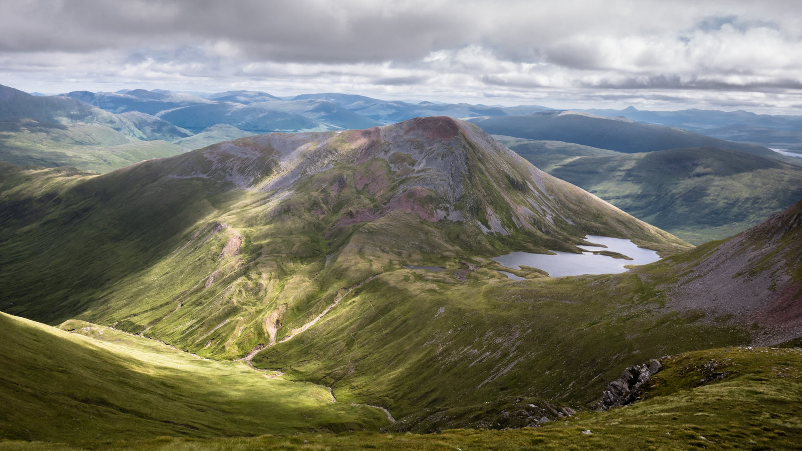
The large coire formed by the two Binneins and the two Sgurrs is a classic example of glacial landscape. The retreating glacier left behind huge moraine deposits, forming spectacular steep ridges and dykes, the true nature of which is exposed at the couple of places where the vegetation has eroded, and the very ancient record of history is laid bare for all to see. The gravelly river itself too reminds me more of the untidy watercourses of the Alps than your typical Scottish mountain stream.
Rather than following the zigzag path, I take one of the moraine ridges into Coire an Lochain, then head up Sgurr Eilde Mor. The geology changes, the red tones of the hill due to significant presence of red granite. I find a small hollow sheltered from the worst of the wind and have another couple of oatcakes and Comte, then brace myself for the wind on the summit.
The gently sloping north east ridge Sgurr Eilde Mor again lies outwith the Munroist lands, and there is no path on it to speak off. It's a glorious afternoon, the sun is out, the sky is blue, and as I descend the sodden and slimy slopes of Meall Doire na h-Achlais toward the river, I spot a couple of walkers sunning themselves on the beach below near the river junction. We say hello as I wade across and follow the watercourse up north.
It's time to look for a suitable campsite. My original plan was to camp bit further on in the bealach between Meall a'Bhurich and Stob Ban, but it's far too windy for a high level camp. The opportunities down here are limited, the ground is saturated with water and the grass is very tussocky, but I find a good spot on a large flat sandy deposit inside the crook of the river. It's about 18 inches above the river level, and from the vegetation it would appear it does not flood too often, perhaps only during the snow melt.
The rain arrives not much later, and I have an early night. After getting an updated forecast on the InReach SE (heavy rain throughout the night and tomorrow), I make a slight revision to tomorrow's plans (deciding to leave out the two Sgurr Choinnichs), then listen to Michael Palin narrating Ian Rankin's Knots and Crosses; the Irish-sounding fake Scottish accents are mildly amusing, and I wonder why they could not get a native speaker to do the reading, but the story is too good to be spoilt by that.
It rains steadily all night and the sound of the river gradually changes. I eventually poke my head out to check on the water level, but there are no signs of it spilling out yet, and so I continue to sleep soundly till half seven.
Day 2 -- Grey Corries (27km, 1,750m ascent, 8h)
I start the day by knocking over the first pot of boiling water, but eventually get my coffee and porridge. The river rose by about six inches during the night. The rain has turned into light drizzle, cloud base is at no more than 600m. It is completely still, and as I faff about the midges are spurring me on.
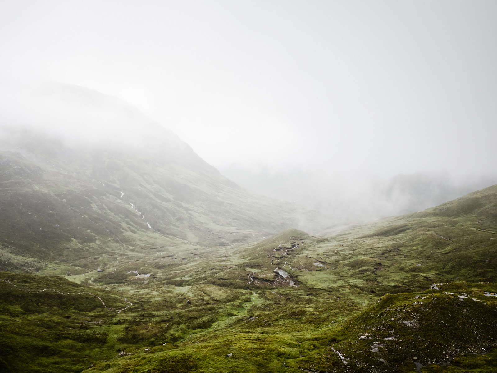
I soon head into the clouds, up Meall a'Bhuirich, where I come across a family of ptarmigan, apart from the numerous frogs, the first real wildlife since the hare I saw yesterday morning. The chicks are quite grown up by now, and they seem unfazed by my presence. At the summit of the roundish hill I have to get the compass out, the visibility is no more than 30 yards and it would be easy to descend in a completely wrong direction.
More ptarmigan on Stob Ban, but no views from the summit. I was planning to descend directly into the bealach above Coire Rath, but this side of the hill is very steep and in the poor visibility I am unable to judge if this is, in fact, possible. I decide to take the well defined path heading east instead, and then traverse the north side of the hill at around the 800m contour line.
This proves to be a good choice and I even pick up a faint, runnable, path traversing at around 780m; perhaps an old stalkers' path. The cloud has lifted a bit and I am now just around its bottom edge; the views down into the coire are absolutely magical. While there is much to be said for sunshine, I have found over the years that some of the most precious moments in the hills come when there is none.
I stop at the wee lochan for a bite to eat, and to have a drink, as this is the last water source until after the Grey Corries.
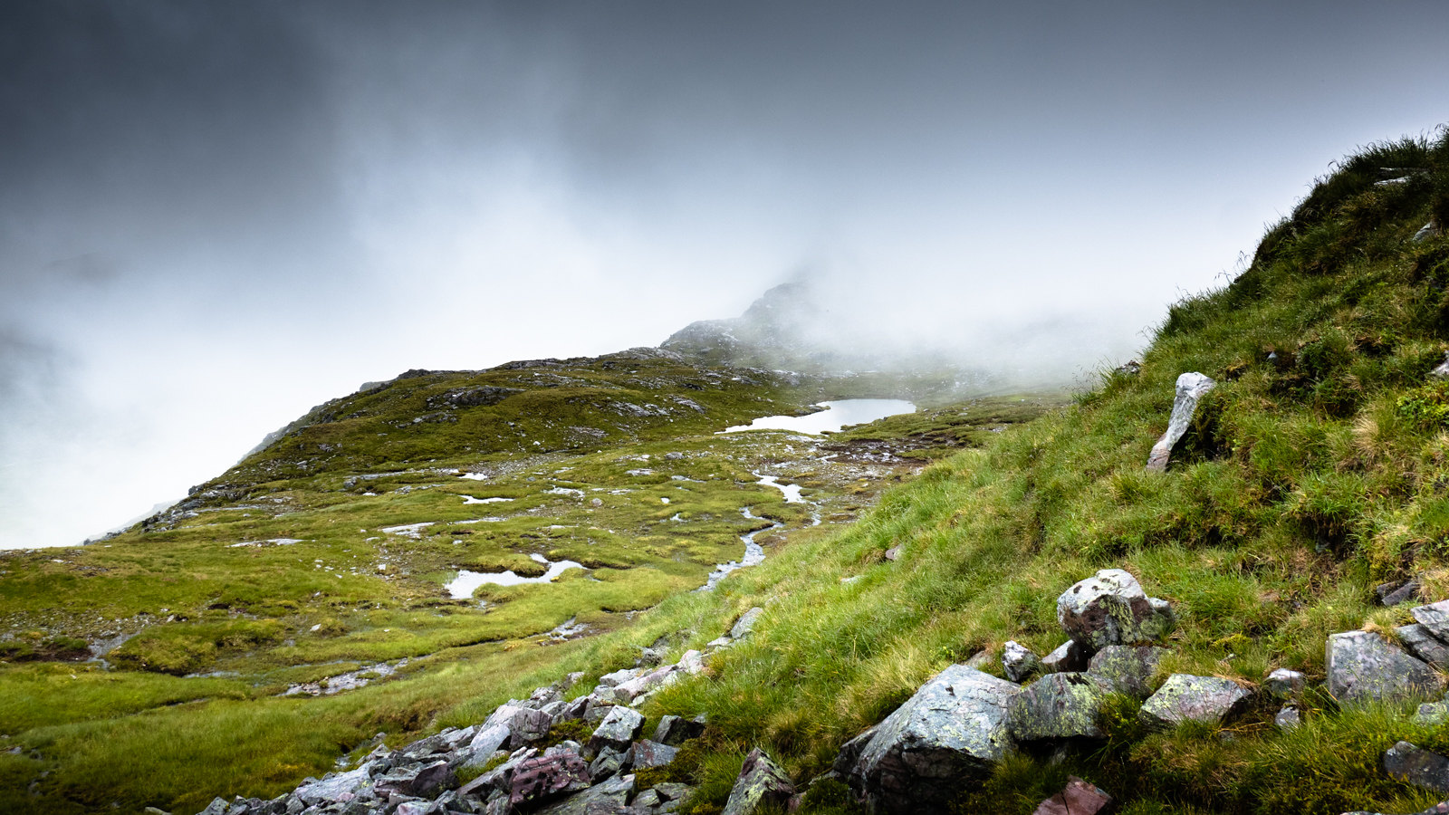
The Grey Corries quartzite ridge line is very fine and dramatic. The low cloud makes it even more so. While it would be hard to get lost here, I realise this is a great opportunity to practice some micro navigation, and so carefully track my progress along the ridge. The running is hard and very technical, and the wet quartzite is rather slippery. I make a mental note that if I ever decide to attempt the Ramsay solo, I should do so in a clockwise direction, so as to get the most serious and committing part of it out of the way on fresh legs (sod the aesthetics of finishing with the Ben!).
My plan is to go as far as the bealach before Sgurr Choinnich More and then descend through Coire Easain into Glen Nevis. The final part of the Stob Coire Easain south west ridge proves quite tricky. Pure, white, blocky quartzite abounds, and in the present conditions it is as slippery as a Zamboni smoothed ice ring -- I am taking my time not to inadvertently reach the coire head first. An unkindness of six or so ravens is circling noisily around me, and somehow in these eerie conditions, that group name seems more than appropriate.
Near the very end of the ridge, the quartzite seems to turn pink, almost red. On close inspection, the colour is due to a fine layer of lichen (my uninformed guess is Belonia nidarosiensis, but I could be wrong, not least since the alternative name Clathroporina calcarea suggests a somewhat different habitat). Under one of these large blocks there is a tiny spruce seedling, trying to carve a life for itself. I wonder where it came from, perhaps the seed arrived on the wind, perhaps attached to the sole of someone's boots; either way, it would have come some distance. I wish it good luck, for it will need it.
A quick stop for water and the last of my oatcakes and cheese, and then down Coire Easain. Up close and personal this turns out to be a real gem of a place. Whereas from above it has the appearance of a simple bowl, it is in fact a series of wet, bright green, terraces (sphagnum moss and frogs abound), with a myriad of small pools from which numerous quickly growing streams start their life, eventually joining up into the mighty Allt Coire Easain. There are a couple of large quartzite escarpments, the lower of which is clearly visible when looking up from Glen Nevis. With a little care, wet feet notwithstanding, this can be descended through the grassy break next to the east bank of the main stream.
I cross the stream, and head south on a gently descending traverse, more or less aiming for Tom an Eite. The ground runs well, until it becomes more tussocky near the floor of the glen. I negotiate the edge of the peat hags by Tom an Eite, cross the beginnings of the Water of Nevis and start following Allt Coire a'Bhinnein along its western bank.
Initially, before a faint deer track appears, this is a bit of a trot through bog grass and peat hags strewn with numerous stumps of ancient Caledonian pine. I try to picture what it would have looked like before man came with an axe and a saw. It would have been quite a different, better, more vibrant, landscape. I am, inevitably, thinking of the previous weekend with Linda, the lovely running among the pines in upper Glen Quoich, and the encouraging progress of regeneration on Mar Lodge Estate. Perhaps one day we will see the pines returning here as well.
Nevertheless, this is yet another gem of a landscape. Midway up into the coire, for two, maybe three hundred yards, the river, at this point at least five yards wide already, is squeezed into a channel between two vertical plates of quartzite only a couple of feet apart. The effect is dramatic; I am peaking over the edge with a degree of unease, falling in would not bode well. I spot a ringed plover, and a short while later a ringed ouzel -- it's good to see some other life than the red deer which abounds.
Just above this constriction in the river, Allt a' Gharbh Coire is coming down on the right in a spectacular waterfall. I am taken aback by the sight, thinking this is, by far, the most dramatic waterfall I have seen in Scotland -- it is only a few weeks back since I watched the famous Eas a' Chual Aluinn from the summit of the Stack of Glencoul, but the waterfall I am looking at just now is in a different league. (I am so gobsmacked by the sight it never occurs to me to take a photograph!)
Soon I am climbing up to Coire an Lochain for the second time this trip -- this time I take the zigzags, my legs are beginning to feel tired. But soon I am on the path that skirts Sgorr Eilde Beag, which provides a most enjoyable run back down to Kinlochleven. As I come around the 'corner' formed by the south ridge, I bump into a group of youngsters heading up to the coire on an (DoE?) expedition.
'Does it get flatter soon?!'
They are the first people I have seen, never mind met, since yesterday afternoon -- on reflection there are benefits to weather less then perfect after all!